Roke Down:1.
Barely discernible (Code number in the book Dorset Barrows. LVG 48b).
2. Barely discernible (LVG 48a).
3. Diameter 55 feet (16m), height 1 foot (0.3m) (LVG 48).
A group of three barrows on the south side of the Milborne Road, west of Roke Barn.
They are marked on the 1811 ordnance map but not on current maps, and may therefore be the remains of a group of three excavated in 1844 and 1845.
4. Diameter 70 feet (21m), height 3 feet (lm). On the south side of the Milborne Road, east of Roke Barn. (LVG 41).
5. Diameter 60 feet (18m), height 3 feet (lm). Immediately behind Haywards Farm on the north side of the Milborne Road. (LVG 44).
6. Diameter 60 feet (18m), height 1 foot (0.3m). North of Haywards Farm (LVG 45).
7. Diameter 60 feet (18m), height 1 foot (0.3m). North of Haywards Farm (LVG 46).
8. Diameter 105 feet (31m), height 3 feet (lm).
It is marked as a long barrow on current ordnance maps and shown as such on map (Fig. 2c, No 2.) but its shape is new somewhat indistinct and may be a round barrow (LVG 38).
9. Diameter 66 feet (20m), height 1 foot (0.3m).
There are three sarsen stones in the hedge nearby, one of which is large, and this barrow may therefore be the remains of one excavated in 1840, which is said to have contained sarsen stones (LVG 39).
10. Diameter 66 feet (20m), height 3 feet (lm). Many flints can be seen on its surface (LVG 40).
11. Diameter 60 feet (18m), height 313 feet (lm). East of Haywards Cottage (LVG 36).
12. Diameter 66 feet (20m), height 3 feet (lm). East of Haywards Cottage (LVG 4).
13. Diameter 66 feet (20m), height 312 feet (lm).
On the parish boundary with Winterborne Whitchurch. Appears to be extensively used as a burrow by rabbits (LVG 35).
14. Diameter 72 feet (22m), height 12 feet (0.5m) (LVG 37).
15. Diameter 90 feet (27m), height 3 feet (lm) (LVG 42).
16. Diameter 54 feet (16m). Barely discernible (LVG 43).1
7. Diameter 60 feet (18m). Barely discernible (LVG 43a).No.'s 15, 16 and 17 are a group of three north west of Roke Pond, two of which are barely discernible and perhaps the remains of excavations.Bere Down:
18. Diameter 60 feet (18m), height 12 feet (0.5m). West of Bere Down Farm (LVG 1).
19. Diameter 36 feet (11m). Barely discernible, west of Bere Down Farm (LVG 2).
20. Diameter 36 feet (11m). Barely discernible, west of Bere Down Farm. (LVG 3)21. Diameter 50 feet (15m), height 1 1/2 feet (0.5m). (LVG 5).22. Diameter 50 feet (15m), height 3 feet (1m).
On the edge of the hill west of Elderton Chump (LVG 5).
23. Barely discernible (LVG 7).
24. Diameter 85 feet (25m), height 6 feet (1.8m). Near the Roman Road.
A very fine barrow - one of the largest and most prominent in the parish (LVG 8).Bolton's Barrow:
25. Diameter 80 feet (24m), height 1 foot (0.3m). In the triangular field between the Wimborne& Kingston roads. (LVG 9).
26. Diameter 70 feet (21m). South-south east of No. 25.
It is not really discernible on the ground, but has been observed from the air as crop marks by the Royal Commission on Historic Monuments, and said to be a low circular mound within two concentric ditches (LGV 9a).Bere Wood:
27. Diameter 72 feet (22m), height 8 feet (2.5m).
A very fine barrow, exceeding No. 24 in height, but only visible at close quarters due to the trees growing on and around it. (LVG 30).
28. Diameter 45 feet (14m), height 1 foot (0.3m), In the field west of Bere Wood, and north east of Woodbury Hill (LVG 18).
29. Diameter 40 feet (12m), height 32 feet (lm) (LVG 31).
30. Diameter 40 feet (12m), height 4 feet (1.2m) (LVG 32).
31. Diameter 45 feet (14m), height 6 feet (1.8m) (LVG 33).
No.'s 29, 30 and 31 are a prominent group of three along the north side of the path from Woodbury Hill.
Trees and bushes are growing on them.
32. Diameter 45 feet (14m), height 5 feet (1.5m). South of the above group (LVG 34).Muddox Barrow:
33. Near Muddox Barrow (or Skippets) Farm.
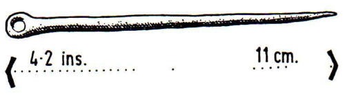
No longer existing, but a bronze axe-head was found on the site in about 1900 (LVG 10).
Standbarrow:
34. Diameter 66 feet (20m), height 3 feet (lm).
On the summit of a large natural bowl-shaped hill, and its size is therefore difficult to determine.
The surmounting barrow can, however, be clearly seen from the south. (LVG 26).Barrow Hill:
35. Not a round barrow, but included on the map and the list because of its name.
It is so large that it would appear to be basically a natural formation.
Formerly known as Bugbarrow, meaning the bent or bowed earthwork.
The Saxon word 'beorg' from which the word barrow is derived meant 'to protect', and was probably formerly used in a loose sense to describe any man-made earthwork.
Barrow Hill, in spite of its name, could therefore be some other form of defensive earthwork, possibly of the Iron Age (LVG 25).Black Hill:
36. Diameter 40 feet (12m), height 2 1/2 feet (0.75m).
On the eastern slope of Black Hill, known locally as Cow Down, west of Shitterton.
Until recently on heathland, but ploughed and sown with grass in 1968 (LVG 17).
37. Diameter 45 feet (14m), height 4 feet (1.2m).
On ridge of hill (LVG 22).
38. Diameter 45 feet (14m), height 3 1/2 feet (lm). On ridge of hill (LVG 19).
39. Diameter 45 feet (14m), height 3 feet (lm). Most northerly of a group of three, the other two being in Turnerspuddle parish (LVG 21).
40. Diameter 42 feet (13m), height 3 1/2 feet (lm). Overgrown with gorse (LVG 20).41.
At Black Hill Clump on the parish boundary with Turnerspuddle.
This is a bell barrow where the main mound is centrally situated on a circular raised platform called a berm.
The berm in this case has a diameter of 150 feet (45m) and is raised some 5 feet (1.5m) above natural ground level.
The central mound has a diameter of 66 feet (20m) and is a further 5 feet (1.5m) high (LVG 18a).
42. Diameter 66 feet (20m), height 6 feet (1.8m). Known as `Hundred Barrow', it is very fine and prominent, formerly on heathland, but now uniquely situated in the garden of a private dwelling.
When the county was divided into `Hundreds' rather than parishes, this was probably the traditional meeting place of Barrow Hundred which neighboured Bere Hundred on the south (LVG 27).Bere Heath :
43. Diameter 66 feet (20m), height 8 feet (2.5m). Known as `End Barrow' it is prominently situated on the strip of heathland on the east side of the main road north of Chamberlaynes.
The original ditch can be clearly seen on the west side.
Narrowly missed by a German bomb in 1940, the crater of which remains nearby (LVG 28).
44. Diameter 35 feet (10m), height 7 feet (2m).
East of Snatford Bridge on heathland with pine trees growing on and around it.
Traces of the original ditch are visible (LVG 24).
45. Diameter 45 feet (14m), height 10 feet (3m). A very imposing barrow east of the above, near Lockyers Hill, and known as `Yon Barrow', with pine trees on and surrounding it (LVG 29)
Nearby, on the summit of Lockyers Hill, there is a curious crater like depression with a diameter of some 72 feet (22m) surrounded by a circular bank 5-6 feet (1.5-2m) above natural ground level.
The crater-like depression could be a natural formation but the bank would appear to be man-made.
46, Diameter 50 feet (15m), height 7 feet (2m).
On heathland north east of T'anpits Bridge, with pine trees on and surrounding it.
There is a complete, well defined surrounding ditch, but this is apparently due to renovation work by the Forestry Commission.
A depression radiating from the centre would appear to indicate previous excavation.
Formerly known as 'Fox Barrow' according to Isaac Taylor's estate map of 1777 (LVG 12).
47. Diameter 57 feet (17m), height 5 feet (1.5m). On the top of Gallows Hill. Damaged by military vehicles (LVG 11).
48. Warren Heath. Marked as a barrow (Tumulus) on some ordnance maps, but omitted on more recent editions.
It is a long mound with a ditch on the south side, and is believed to be an old rifle butt (LVG 47).
49. Warren Heath. Formerly on heathland, but now ploughed over and considerably reduced in height.
In 1953 it had a visible ditch and was hollow in the centre (LVG 23).
50. Diameter 75-100 feet (23-30m), height 5 feet (1.5m).
On Lower Hyde Heath. It is not perfectly round, and could be a natural formation (LVG 13).
51. Diameter 84 feet (25m), height 5 feet (1.5m).
On Lower Hyde Heath. Another possibly natural formation (LVG 14).
52. Diameter 50 feet (15m), height 5,1 feet (1.6m) (LVG 15).
53. Diameter 48 feet (14m), height 6 feet (1.8m) (LVG 16).No.'s 52 and 53 are on heathland alongside the road from Gallows Hill to Wareham.
Both have visible ditches, and have been damaged by tanks. Very creditably, the present owners have fenced them and erected an explanatory notice board.
Towards the middle of the last century, when the old open fields were being enclosed and when farms were developing into the form in which we now know them, it became common practice for many farmers to bring what had formerly been open downland under cultivation, and to dig away barrows in order to use the chalk of which many of them were formed to lime their fields.
This brought about a spate of barrow digging by collectors and archaeologists as a kind of rescue operation to recover any urns or other objects from the barrows before they became scattered over the field as so much debris.
Unfortunately, these excavations were often hastily undertaken by gangs of labourers under the direction of archaeologists whose prime interest was in acquiring the urns which the barrows might contain.
Consequently the field notes and subsequent accounts are often vague not to say inaccurate or contradictory.About a dozen barrows on Roke Down and Bere Down were opened in this way between 1840 and 1850, and the three more or less contemporary published accounts are conflicting in many respects.
The three accounts may be found in Hutchins' History of Dorset, 3rd Edition (1861), Warne's Celtic Tumuli of Dorset (1866) and the Durden Catalogue (1891).
The two archaeologists chiefly concerned in the Bere Regis burrow excavations were both Blandford men-Henry Durden, primarily a collector, and William Shipp, author of the third edition of Hutchins' History of Dorset.
The basic field notes and various subsequent written up versions seem to have formed the basis for all three published accounts, and the conflictions in the manuscripts were further added to in one version by a printers error in the order of some of the illustrations. Even further confusion arose as a result of the lack of a firm line of demarcation between Roke and Bere Downs when the same barrow is referred to as no. 4 on Roke Down in one account and no. 1 on Bere Down in another.
However, what the nineteenth century archaeologists lacked in accuracy they made up for in verbosity; in referring to the perfectly preserved teeth in three skeletons, Warne says there were "clear indications that their possessors had terminated their earthly existence at no advanced period of life".
Whatever we may now think of the Victorian archaeologists and their lax and inaccurate recording of excavations, there is no doubt that but for their efforts many Bronze Age objects now safely housed in museums would have been lost for ever.Henry Durden amassed a considerable collection of Bronze Age material from various parts of Dorset during his lifetime, and after his death the whole collection was acquired in 1892 by the British Museum and the Roke and Bere Down urns which formed part of it are now to be found there.In the following simplified accounts of the excavations the `LVG' numbers quoted are the Bere Regis barrow numbers given in L. V. Grinsell's Dorset Barrows in which all known barrows, existing and previously excavated, are listed parish by parish:
A. Roke Down
A barrow was opened on Roke Down in about 1785, but no urns recovered from it are known to exist, and nothing is known about the excavation work, beyond the fact that large stones were found placed over the urns.
The following note appeared in the Dorset County Chronicle in 1825: "Several of these stones remain to this day on the original spot, where stood the mound; others were removed and placed around a cottage, by the River Piddle, by way of a defence.
I have seen most of them, and likewise an old man, who forty years ago assisted in their removal.- J. F. Pennie." At the present time several very large sarsen stones may be found a short distance south east of Barrow number 10 (see previous map) at the junction of two hedges on the east side of the lane, and may, therefore, denote the site of this barrow.
B. Roke Down
(LVG 46a). Diameter 56 feet (17m), height 10 feet (3m).
Opened on 9 October, 1844, by Shipp and Durden, its position was vaguely given as on the upper part of Roke Down. It contained a number of cremated remains, four skeletons, one urn broken beyond recovery and five complete urns. One urn contained two "stone amulets" and its upper rim was missing.