Bere Regis Village Website

Bere Regis Manor


The Manor of Bere Regis was a large one, comprising almost the whole of the present day parish, except for Shitterton and Hyde which were separate small manors in their own right.


As referred to before, it had been one of the royal manors in Saxon times, at least before the year 978, and continued as such up to and during King John's reign (1199-1216) when he stayed here on at least 16 occasions.
After King John's death it passed automatically to King Henry III (1216-1272), but in 1259 it ceased to be royal demesne when it was granted to Simon de Mcntfort, Earl of Leicester.

Simon de Montfort was thus the first private owner of the manor and a word should perhaps be said about him.
He was a most powerful and influential person in national affairs in both England and France, and was as a result continually either in or out of favour with the king.
In 1238 he married Eleanor, the king's sister, and then began a lengthy legal argument over the form and amount of the marriage settlement, which was eventually resolved when the king granted Simon ten English manors, one of these being the manor of Bere in Dorset.
it would appear that Simon de Montfcrt's officials took possession of the manor in what may be termed indecent haste, as the king was required to intervene on behalf of the Abbess of Tarrant whose early crops were being seized by Simon's bailiffs.
Simon de Montfort's chief claim to fame lies in his successful efforts towards the reformation of the English parliament, and he is therefore often considered as its founder. In 1265 when he led an uprising of barons against the king, he and his supporters were defeated at the battle of Evesham when Simon de Montfort himself was killed.

After Montfort's death all his property was reclaimed by the Crown, so that the manor of Bere again became royal demesne for four years, until 1269 when it was granted to the king's brother Edmund, Earl of Lancaster and his heirs.
Later, however, the manor appears to have formed part of the estates of the Earls of Hereford, under whom the Turbervilles became tenants and hence lords of the manor.

The Turberville family have been dealt with more fully in the previous chapter, and for most of the time they were not the sole possessors of the manor, for the successive Abbesses of Tarrant held a moiety (half the rents and profits) of it until the dissolution of the abbey in 1539.
In 1547 Robert Turberville purchased the moiety which had belonged to the abbey, thereby procuring the whole manor for himself and his heirs.
Although Tarrant Abbey's moiety is recorded as being granted by Edmund the king's brother when he received the manor in 1269, this was probably confirmation of an existing arrangement, as the Abbess of Tarrant appears to have already had some claim on the manor in 1259 when it was granted to Simon de Montfort.

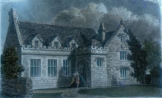
Tarrant Abbey was situated at what is now Tarrant Crawford, the southernmost of the Tarrant villages, near Spetisbury, and was founded in 1230 for Cistercian nuns. Its 309 years of history seem to have been uneventful, and when it was surrendered at the Dissolution in 1539, it was the second largest monastic establishment in Dorset with 20 nuns.
The last abbess, Margaret Russell, was given a pension and may well have retired to Bere Regis, for in her will dated 1567, she desired to be buried in this church.

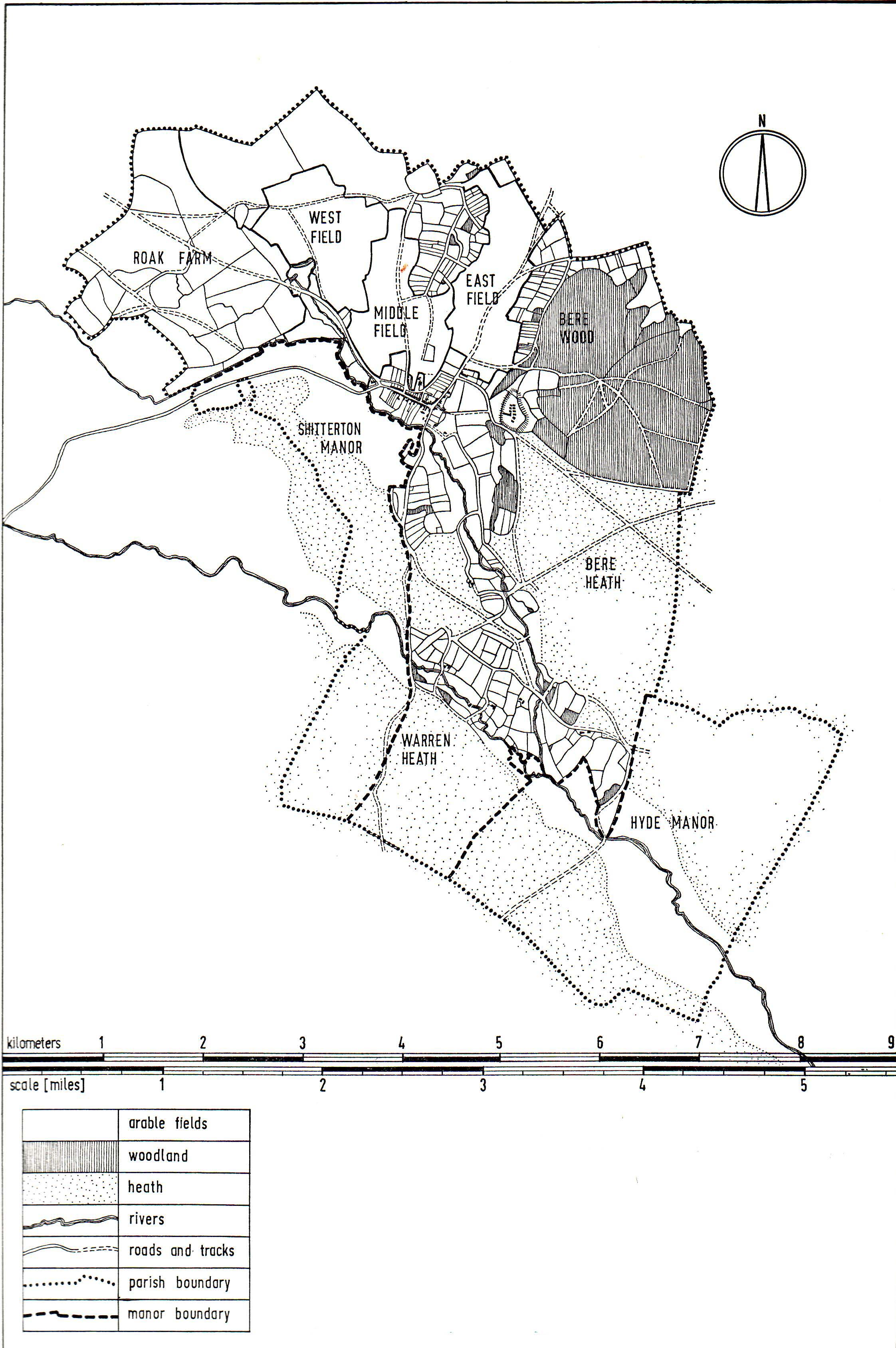
In 1291, the abbess's moiety in rents from the manor of Bere amounted to £16 5s. lOd., and in 1293 she claimed to have a moiety of a "fair, market, free warren, and the whole forest of Bere."
By 1535 the value of her moiety of the manor had increased to £29. 12s. 2d., as this extract from the Valor Ecclesiasticus of that year shows:

Manor cf Bere, worth per annum, namely in rents of assize ................................ £21 1s 6d.
In demesne lands to farm at will, namely in uncertain rents:

wheat, 9 quarters 6 bushels .............................................................. £2 12s. Od.
barley, 6 quarters. 6 bushels .................................................................. 18s. Od.
oats. 12 quarters ................................................................... 16s. Od.-£ 4 6s. Od.

In pasture for 600 rams in the occupation of the abbess, per annum .......................................................................................................... £2 10s. 0d.

In profits at the fairs at Wodeburyhyll, within the said manor, communibus annis ................................................................................................... £2 0s. 0d.

In profits of courts, namely in heriots, fines and other perquisites, communibus annis ....................................................................................................... 16s. 8d.

Total £30 14s. 2d.

And in rents, resolute to the Sheriff of Dorset, at his tourn, held at the Cross of Bere, issuing out of the aforesaid manor of Bere annually ..................... 12s. Od.
And in fees to Roger Gye, bailiff of the same manor of Bere annually ............... 1Os. Od.

Total £ 1 2s. Od.

This account therefore shows an income of £30. 14s. 2d. less an expenditure of £1. 2s. Od. showing the abbess to have made a profit on the manor of £29. 12s. 2d. Another account of 1539 shows the income as follows:

Rents of free tenants ................................................................................. 2s. 4d.
of customary tenants .. ..................................................................... £15 18s. 4d.
for the farm of the capital mansion, manor, land etc........................... £ 8 16s. 6d.
for the farm of demesne land ............................................................. £ 5 17s. Od.
and from perquisites of court .................................................................. 19s. 8d.

Total £31 13s. lOd.

A family named Bridport or de Bridport (originally from the Dorset town of that name) seem to have been concerned with property in Bere at an early period, and to have been lessees of the Abbess of Tarrant.
John de Bridport who had been one of the burgesses of Bridport in 1313 and who was later knight of the shire for Dorset in 1322, is mentioned as lord of the township of Kyngesbere in 1316.
Also, a charter of uncertain date was granted to Isabel, the wife of John Brideport, to hold a three days fair in Bere.

The Turberviile family are mentioned in connection with Bere as early as 1202, but it is not known exactly when they became lords of the manor. However, John de Turberville is known to have been lord of the manor in 1274, and successive heads of the family remained so until 1704 when the last male heir, Thomas Turbervilie, died.
His wife and three daughters continued to act as "ladies of the manor" until the estates were purchased by Henry Drax in 1733.
The manor still remains in the possession of that family, although many smaller portions have now been disposed of to individual owners.

A few years after acquiring the manor, Henry Drax commissioned a famous surveyor and map maker, Isaac Taylor of Ross, Herefordshire to survey the whole of his estates at Morden, Charborough and Bere.
This survey took four years to prepare, from 1773 to 1777, and the Bere manor occupies eight large scale maps.
Every parcel of land is shown in detail together with its area and the name of each tenant, and where in the village itself the plots of land tend to be smaller, there is an accompanying`terrier' or list of properties and tenants.
The three large open fields north of the village were divided into strips rather like allotment gardens and cultivated in three-yearly rotation, and the boundaries between them can still be readily identified.
The maps are surprisingly accurate, and as many features which still exist can be readily recognized, it has been possible to condense the information on to one smaller scale map with the aid of modern ordnance maps.
See the map below -

The unfenced divisions of the three open fields (East Field, Middle Field and West Field) have been omitted for clarity.
Where portions of the open fields were on steepish slopes the strips were usually arranged to run with the contours of the hill, and in such cases centuries of ploughing caused the strips to become terraces with dividing banks between, known as `butts'.
Such an example occurs in the existing small field west of barrow hill, where a tongue of `Middle Field' reached down to the present Tower Hill, and in which the `butts' can still be clearly seen.

One of the maps showing "the town of Beare Regis" is of particular interest as it gives a large scale representation of the village as it was before the serious fire of 1788.
For this reason it has been reproduced separately to a larger scale, and is drawn from a combination of modern ordnance maps and Isaac Taylor's map - see the map below -
There are many features of interest, but perhaps the most notable is the road system which lacks the present day Poole and Dorchester Roads, not constructed in the form in which we know them until 1840.
All routes eastward were by way of Townsend, Woodbury Hill and the Wareham Road, and the main westerly route was by way of Shitterton and the present Dark Lane.

The manor house stood in what is now Court Green immediately south west of the present Court Farm cottages which appear to have been adapted and rebuilt from the east wing and outbuildings of the old house.
The original manor house would have been built during the Anglo Saxon period when the village itself was first established, and was the building in which Queen Elfrida stayed in 978.
It then probably remained in more or less its original state until King John's time (1199 - 1216) when it was repaired and considerably enlarged to provide suitable accommodation for him and his court on sixteen occasions during his reign.
At some time during the 13th century it became the residence of the Turberville family as lords of the manor until the extinction of that family in 1704, although Thomas Turberville's widow and daughters who survived him presumably continued to live in the house until the manor was sold in 1733.
During this period from the 13th to the 18th centuries the house underwent many alterations and extensions to say nothing of repairs and rebuilding. In King John's time manor houses were usually in the form of a group of detached rooms, and this period of some five centuries would have seen the house develop into the single irregular block which it had become in later times.
When the manor was sold to Henry Drax in 1733, he and his successors being already established at Charborough, the Bere manor house ceased to be used as such from that date.
Consequently the state of the building rapidly deteriorated, and although it was still standing in 1803, it had disappeared by 1844.

From Isaac Taylor's 1777 map (previously shown) the house appears to have been basically quadrangular with a central courtyard, and according to the 1662 hearth tax returns it had 16 fireplaces.
There is now nothing to be seen above ground on the site (though doubtless the foundations still exist under the turf) but it is fortunate that two old drawings of the house still exist, and they are reproduced below.
The top one appeared as an engraving from an earlier drawing showing the west side, in the 1861 edition of Hutchins History of Dorset, and the bottom one is an original ink and wash drawing of the eastern side, in 1786, by J. B. Knight in the Dorset County Museum.
In the second drawing an outbuilding on stone staddles which still exists can be identified and helps in locating the position of the main building.
When Hutchins visited the house in about 1770, he described it as "of stone, large but irregular".
The arms of Thomas Turberville who died in 1587 appeared on part of the west front, denoting that this portion had been added or rebuilt during his lifetime, and the date 1648 appeared below a window at the back of the house.
The hall or principal room was described as "a pretty large room," and on the walls were hung the various arms of the family.

After the house had collapsed or been pulled down early in the nineteenth century, a considerable pile of rubble must have remained on the site, and seems to have been used as a quarry for much of the building activity in the neighbourhood, as stones from the house may still be found in various parts of the village, besides many more which must be built in and now out of sight.