Bere Regis Village Website

Bere Regis Village Geld Rolls 978 - 1086


From the time of Ethelred (978 - 1016) most of England was subject to a tax called Danegeld, for which purpose Geld Rolls were compiled and the tax was collected annually until 1084.
At this time each County was divided into large administrative areas called Hundreds and at the time of the Domesday Survey (1086) there were 39 of such Hundreds in Dorset.

These Hundreds were much larger than the present day civil parishes of which there are now some 270 in Dorset and the Hundred of Bere (there was no 'Regis' at this time) in 1086 consisted of the present day parishes of Bere Regis & Winterborne Kingston, Milborne Stileham and Milborne Deverel, being those parts of the present Milborne St. Andrew parish east of the stream. Affpuddle and Turnerspuddle parishes, Bovington being that part of Wool parish north of the river Frome.
The part of East Stoke parish north of the Frome, Worgret, being that part of the present Arne-Stoborough parish east of Wareham and north of the Frome and a small portion of Wareham Lady St. Mary parish.

Thus it can be seen that the whole of the southern boundary of the hundred was formed by the river Frome with a kind of peninsula projecting as far as Wareham, bounded by the two rivers Piddle & Frome.
The neighbouring Hundreds were Puddletown on the west, Coomsditch on the north and east and Chalbury, Winfrith and Hasler on the south. See the Map of the Bere Hundred in 1086 below.
The hundreds continued to form the basis for all official surveys and lists until comparatively recent years, at least until about 1880, but they underwent many boundary changes during this time.
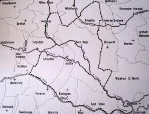
For example, the original Bere Hundred became divided into two when the southern portion seceded, as it were, and Affpuddle, Turnerspuddle, Shitterton and Hyde, besides Bovington and parts of East Stoke became Barrow Hundred.
It is perhaps of interest that of all the Dorset place names occurring in the Domesday survey, only two, Frome (Vauchurch) and Bere are spelt as at the present time.

From early Saxon times, certain manors belonged exclusively to the Crown without an intervening tenant or sub-tenants and were known as Royal Demesne.
There were about 30 of such manors in Dorset and Bere was one of them. As Royal Manors they did not come under the jurisdiction of the Hundreds and were not of course liable to tax, so that they are not listed individually in either the Geld Rolls or the Domesday Survey, but are dealt with collectively in six groups.
These six groups of Royal Demesne are in neither alphabetical nor geographical sequence, as Bere occurs in the second group together with Bridetone (Burton Bradstock), Colesberie (part of Sturminster Newton), Sepetone (Shipton Gorge), Bratepolle (Badpole), Cidihoc (Chideock) and parts of Whitchurch Canonicorum and Kingston Russell.

In both the Geld Rolls and the Domesday Survey the main unit of area used is the Hide.
It was not strictly a measurement of area, but meant rather a farmstead unit and was a sufficient amount of land to employ a team of oxen.
The Hide was subdivided into four virgates or 48 acres (i.e. 1 Hide = 4 Virgates and 1 Virgate = 12 Acres). As the area of the hide seems to have varied from Hundred to Hundred, there is no exact modern equivalent, but it is usually taken as equal to about 120 modern acres (48 hectares).
A Domesday acre is thus seen to be approximately a hectare.
The Hundreds were probably originally so called because they contained 100 Hides or Farmsteads and would account for the larger size of those Hundreds which contained large areas of uncultivated heathland, as such unused areas were neither scheduled nor taxed.
It may be supposed that the Royal Manor was of about the same extent at the time of the Domesday Survey as in the 18th Century for which there is an accurate Map, but in former times it does not appear to have included at least a part of Doddings.
In the following extract from the Geld Roll, translated from the original Latin, the 49 1/4 Hides referred to do not include the Royal Manor:

XV. Bere Hundred. In Bere Hundred there are 49 hides and 1 virgate.
Thence the King has £9.8s (£9.40) for 31 hides and 1 virgate and the Kings Barons have in Demesne 17 hides less 1 virgate.
Of this Demesne the Count of Mortain has 1 hide and Hugh Gosbert 1 virgate and Aiulf 1 hide. Alvric the Huntsman 2 hides.
The Abbot of Milton 1 hide. Godric the priest 4 hides less 10 acres.
The Abbot of Cerne 4 hides.
The son of Eurebold 2 hides. And from 1 1/2 hide which Osmund holds of Swain the King did not have Geld and from 1/2 hide which Walter Tonitrwet holds of the wife of Hugh the King never had Geld and from 1/2 hide of land which was Theguland T.R.E (in the time of King Edward) and is now in the Kings Farm the King never had Geld and from 1 1/2 virgates which Edwin the huntsman has in this hundred he paid Geld in another.

The Geld Rolls and collection of Geld continued after the Norman Conquest of 1066, until 1084, but in 1086 King William ordered a new more detailed Survey of his newly acquired Kingdom, the Domesday Survey.